

2024 09 Best of Banff 16.-28.9.24
- Peter van der Gugten
- Nov 18, 2024
- 30 min read
Updated: Jan 28, 2025
The following stories you read where writen by Brent Wray of BC Canada, It is entirely his work and the way he experienced the ride. Pictures and Videos taken by Brent Wray, Christian Barreis and myself.
Best of Banff Tour: Day 1 16.9.
Up early, we checked out of the hostel, grabbed breakfast to eat on the road and headed to Banff to hook up trailers, feed horses and do final preparations. The amount of gear was the same, but allocating 14 days of food (13-day planned duration, plus an insurance day) was going to be tricky space-wise. Previous trips had been in the 7-10-day range; this one would be pushing the limits for an ultra-lite, unsupported adventure with no resupply opportunities. Weight wasn’t nearly as much of an issue given the simple, spartan, lightweight backpacker nature of our food. With the nature of this style of travel, we walk a lot anyway and all of us were in good shape, capable and prepared to do our fair share of walking.
We managed to get everything rationalized and allocated, then loaded the horses and hit the road. First stop, we’d drop my rig at Pipestone trailhead to be our pickup vehicle. Then, we all piled into Peter’s rig and headed to our starting point, Lake Helen trailhead.
As usual, the trailhead parking area was full, but lots of room in the big pullout overlooking Bow Lake on the other side of the highway. We parked the rig, angled, at the one end of the pullout, unloaded the horses, then saddled and packed them right there in the parking lot on the side of the Columbia Icefields Parkway. The biggest challenge was all the folk coming over to take pictures, pet the horses, chat and ask about our planned adventure. One fellow from Vancouver and his friends from Trinidad were particularly interested. It was shortly after 10AM when we were finally able to lead the horses across the highway and hit the trail. Our Best of Banff Adventure was officially under way!
The trail starts climbing, immediately, with occasional breaks in the trees to allow spectacular views down the valley and over to Bow Lake. Lots of day hikers on the trail headed up to Lake Helen. All were very polite and respectful, stepping aside to allow us to pass. Most were very friendly and happy to see horses on the trail, asking where we were going. Something along the lines of “Wow! What an adventure! Have a great trip.” was the typical response.
We watered the horses where the trail crossed Helen Creek, then stopped for a grazing break at Lake Helen, before the final push to Dolomite Pass. The high point of Dolomite Pass (2514m) would be highest pass we’d cross in our entire journey. All in, we’d gained 545m in the first 8km of our journey, not bad, and a very reasonable ~7% grade.
As we crossed Dolomite Pass, it was nothing but easy travel and spectacular views as we made our way to Lake Katherine, where we stopped for lunch, hobbled the horses and turned them loose for an extended grazing break. From there we turned north, and continued our way on the high mountain pass, enjoying the bluebird sky and incredible scenery.
Last year, I’d been on this trail with my friends, Jody and Angela, on our first major, self-guided pack trip with our own critters, gear and skills, and certain points brought back memories. The base of a waterfall, on the far side of Dolomite Pass, was one of those points. In 2023, we had to repack Cookie, my mutton withered, little mule, because her load was slipping. When Jody leaned into the final pull to tighten the lash cinch, the lash rope snapped, sending her falling, unceremoniously, onto her ass in wide-eyed surprise! After many trips, the friction in the same spot as the diamond hitch was completed, had worn the rope and while Jody isn’t that big, she IS mighty. That was all the weakened lash rope needed and it snapped, right there on Day 1 of our planned, extended adventure. Fortunately, I’d learned from my mentors and had the foresight to pack a spare, so it was just a matter of finding it. We were awful careful after that, making the final pull with fingers crossed as we tied our diamond, because we didn’t have another spare.
No such difficulties this time around, we just enjoyed the waterfall and the views as we began our long descent to Isabella Lake.
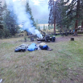
According to Banff National Parks website, the official horse camp is at the south end of Isabella. I had the exact GPS coordinates in my GPS. We wasted a lot of time looking for it in 2022, labouring through somewhat boggy swamp grass. Nothing! I knew better this time, so we just skirted the side of the lake to the great little horse camp we’d discovered in 2023, just south of the Isabella warden cabin. Day 1 was complete with 22km travelled and the highest of our mountain passes successfully crossed. We set up the electric fence enclosure for the horses, ate rehydrated chili for dinner, then rolled out our sleeping bags for a great sleep under a full moon and semi-clear sky.


Best of Banff Tour: Day 2 17.9.
It was roughly 11:30PM when I woke, instantly alert. Something was wrong. Was it just me, or were the horse bells too faint. I propped myself up and listened. My movement woke up Peter. “What is it?” he asked.
“I think the horses are out. The bells are too faint.”
He listened for a moment, then replied “It’s OK. I hear them; it’s fine.”
Knowing Peter, if he thought they were out too, he’d have been up in a flash, putting on his boots to catch them. I rolled over, closed my eyes and went back to sleep.
The next thing I hear is Peter, “Brent, take Charlie and tie him. The horses are out!”, and he hands me Charlie’s lead rope. Chris was hurriedly putting on his boots, then he and Peter left to get Rodeo and Ahi while I tied Charlie to a tree.
Shortly thereafter, Peter and Chris returned with Rodeo and Ahi, tying them to trees. They’d definitely gone through the fence, but hadn’t left. Instead, they were just grazing a short distance away; close enough for us to faintly hear the bells. Horse secured, we returned to our sleeping bags and went back to sleep.
First thing in the morning, we turned the horses loose to graze while we assessed the fence situation. Yup, someone had definitely gone through it. Judging from the long line of fence line down the trail, we’re guessing one of them went through at a midpoint in the fence line, jerking the handle loose and then dragged fence line and handle down the trail, until free of the line. Then they stopped to graze.
Mystery solved, we rolled up the fence line, gathered up strewn parts, had breakfast, packed up camp and hit the trail. We rode steady and cold, in the sunless shadow of the mountain, for almost two hours until we came across a wonderful sunshiney spot: a small, grassy meadow on the edge of a creek. Perfect spot for an extended grazing break!
From there we got into some really technical trail: narrow singletrack through the forest, with rocks, exposed roots, ruts, water, mud and slightly boggy in places. It was slower going, but didn’t faze the horses one bit. Seasoned mountain trail ponies that they are, they just confidently powered through.
Eventually the forest opened up and the terrain opened up to reveal the Siffleur Valley. We stopped on a slight knoll with a great view down the valley for lunch and another grazing break. From our vantage point we could see two mountain passes: Pipestone, to the south, and Clearwater, to the southeast. This was our first key decision point and emergency exit, if we were having trouble. Head south over Pipestone and we would reach our pickup vehicle in two days.
Fortunately, we were problem free, so we turned east, traversing Clearwater Pass, past Devon Lakes to the unofficial horse camp that would be our camp for the night. I still can’t believe our stats for the day. We’d travelled 35km, gaining 540m in elevation over a long, steady climb. Part of that trail was quite technical, necessitating a slower pace. We’d never rushed and we had a couple extended grazing breaks. Yet we’d done it all in less than 8 hours. Charlie had been a trail-eating machine, leading the way, stepping out with the rein a-swinging, keeping time with the rhythm of his pace.
Horses had a great evening grazing break through camp and the adjacent willow meadow along the trail. We had my American Goulash, a dehydration experiment I cobbled together from three separate recipes, for dinner. Clear skies, but we set up the tarp anyway, just in case. Horses were secured for the night in their electric fence enclosure on the hill above us. If any of them went through the fence, they’d have to come through camp to reach the trail.
Tomorrow, we’d ride one of my favourite sections of trail.


Best of Banff Tour: Day 3 18.9.
A great night with no rain or horsey shenanigans. As usual, we got an early start. Less usual was the joy of spending the first hour travelling in sunshine. It wasn’t long before a mountain was blocking the sun, making for a frosty grazing break in the spectacular meadow in front of Clearwater Warden Cabin.
Then, we continued on, enjoying excellent trail, spectacular views, magnificent lakes and zero elevation gain. This is the third time I’ve ridden this stretch in three years and I never get tired of it. First time was with Peter & Tina on the 3rd leg of our Great Divide Trail ride from Grande Cache to the Elk Valley in 2022. Second time was July 2023 on the Best of Banff pack trip with Jody & Angela. Such a lovely trail. The only problem is no matter which direction you come from, you’ve gotta pay a price to get here: 2-days ride and at least one mountain pass to cross.
After taking in the beauty of Clearwater, Martin and Trident Lakes, we continued through the forest until it opened up to Malloch Flats, where we stopped for lunch and a grazing break. After lunch, we continued on excellent trail to the historic Indianhead Meadows Lodge in the far northeast corner of Banff National Park. From there, we left the park, riding 2km to the luxurious Indianhead Meadows horse camp, complete with saddle rails, corral, benches, table, fire pit, rustic toilet, good water and great grazing.
I’ve gotta admit I was a little twitchy, though - the ghosts of pack trips past. It was here, last July, that Jody, Angela and I lost the horses. I woke around 5AM to go check on them and discovered the electric fence line down and the horses gone. We spent close to the next 9 hours searching, listening for bells and tracking them. Thank goodness, we finally found them on the other side of the Clearwater River. Yup, that’s right, four horses and a little mule, all hobbled, travelled about 1km, then crossed a belly deep, flowing river. What possessed them to do that, we have no idea. After finding them, we brought them back and fixed up the old broken-down corral with random poles, large branches and old baling twice and they all spent the night in there. Now, here we are, 14 months later and whadaya know, our redneck corral renovations were still holding.
We unsaddled, hobbled the horses and turned them loose to graze. At first, they just hung around camp, grazing and getting in the way, but eventually they wandered up the trail and found a favourite spot just within bell hearing distance. Every so often, one of us would head up the trail to go check on them, but they were behaving themselves and getting their fill in this particularly tasty meadow, so we let them be. As dusk rolled around, we brought them back and they spent the night in the ramshackle corral.
24km of fantastic trail and no elevation gain today. Tomorrow would be a different story as we tackled the trail up Peters Creek, which required route finding in places, and over Divide Pass.


Best of Banff Tour: Day 4
Up at first light, we turned the horses out to graze. They’d done a good job cleaning up the grass in the corral overnight, but waste no time heading up the trail to their favourite spot from last night. They graze while we have breakfast and break camp, always with one ear listening for the sound of the "happily grazing" bell, as opposed to the "heading down the trail" bell.
On the trail by 8AM, we start out on long-established, rutted horse trail, then cross the Clearwater River and start working our way up Peters Creek. The GPS shows the trail on the righthand side of the creek, and it is for a bit, but Spring runoff and landslides has decimated the trail over the years, so there’s a fair bit of route finding and just grinding up the creek. It’s a tight valley, so even thought there may not be a trail, just stay directionally correct, headed up the creek and it’s pretty much impossible to mess up. But it can be tough, slow going at times.
Fortunately, from our experience on last year’s trip, I knew there was an outfitter’s trail on the lefthand side of the creek that was like a superhighway compared to riding the creek bed, and it’s not shown on any maps, or GPS apps. Last year, we’d been working our way up the creek, watching for any sign of trail on the right, when these two ladies, each with a pack horse, came flying up the lefthand side of the creek. When we went to investigate how they were moving so fast, we discovered the trail, so tucked in behind them and made much better time.
That knowledge saved us a pile of time and effort, as we accessed the trail much earlier and had much better going to where the trail split and we turned off to Divide Pass. Just before we hit the Pass, we stopped at a great little meadow for lunch and an extended grazing break.
We were very hopeful when we got back on the trail that we might see the famous bison herd that had been introduced to the Park in 2018, with 31 animals released. As of 2024, the herd is healthy and has grown to over 130 animals. Jody, Angela and I were incredibly fortunate to encounter the herd last year as we crossed Divide Pass.
Unfortunately, no bison this year. We did encounter a Park ranger who was heading off to check some game cameras. He was stationed at Scotch Camp and would be back later in the day.
From Divide Pass, we continued on to Divide Creek warden cabin. The original cabin, a National Heritage Site built in 1922, still stands. It’s no longer in use for anything other than storage, and a new cabin has been built, but it’s still amazing to see that old building, still standing after all this time. I’m sure it could tell some pretty amazing stories!
There were two more rangers at Divide cabin. We had a great chat with them, as well. Peter mentioned that we’d seen no wildlife in the last four days and asked if they had any idea as to why. The one lady ranger tackled the answer. First, the area is so vast there are plenty of places for them to be off-trail, but she did acknowledge from review of old ranger reports that they weren’t seeing the same kind of numbers that they were 25+ years ago. There were a number of possible reasons mentioned, including climate change, willows overtaking grazing meadows and a few other things, but when all was said and done, they didn’t really seem to know. Many possible causes, in general; but no one thing, in particular.
They asked to see our permits and confirmed all was in order. They were very impressed the adventure we were undertaking, “This is a fantastic trip and you’re going to see some incredible country. It is so cool that you guys are doing this! No one does this sort of thing anymore.”
They gave us the remnants of a bag of horse feed for the horses, and with that we said our goodbyes and were on our way to Scotch Camp. We’d originally planned to stay at Divide Creek, but we’d done better than planned up the Peters Creek stretch, so figured we may as well continue on to Scotch Camp, which was only another few hours of riding. A bit of a climb up a much-used trail, then a gradual descent into the Red Deer River valley. We set up camp near the river, on the edge of a nice meadow with plenty of grazing for the horses. The weather was about to turn, with rain in the forecast and possibly snow higher up, so we set up the tarp.
Later that evening, I heard the horses in meadow whinny and went out to see what had their attention. It was the ranger we’d met on Divide Pass, returning to Scotch Camp. He’d had a good day, accomplished what he’d set out to do and was glad to see us and hear that we had travelled safely. In the course of our conversation, I inquired about what was going on with the designated horse camps. I have the GPS coordinates for every horse camp on our route, taken from the BNP website and so far, we hadn’t found a single one, in spite of proactively searching. No trail, no sign, no camp, no indication of there ever having been a camp. Our Isabella and Devon Lakes camp sites weren’t anywhere near the areas indicated by official Banff GPS coordinates. Indianhead Meadows was the nicest, but it was outside Park boundaries, and so not really an “official” BNP maintained site. Horses aren’t permitted in hiker camp areas, so where do equestrians camp? Why even go through the hassle of booking “official” sites that don’t seem to exist?
He acknowledged that there hadn’t been much maintenance of backcountry horse camping sites for many years, due to low equestrian traffic. With limited manpower and budget, they had to focus time and attention on the higher-use hiker sites and front country areas. As for booking of sites, it was so Park rangers had some sort of idea as to who might be out there and roughly where they might be, in the event of emergency, which made sense. We concluded our conversation and he invited us to stop by the warden cabin in the morning, on our way through.
28km travelled today and Divide Pass crossed. At 2412m, it was the second highest in our journey. With the weather turning, it was nice to have the two highest mountain passes in the rearview mirror. By continuing to Scotch Camp we were now a day ahead of schedule.
Best of Banff Tour: Day 5
It was a good morning. No bison causing a ruckus and stampeding the horses and no overnight grizzly incidents. It was around this time last year that a backpacking couple and their dog were killed by a grizzly in the Scotch Camp area. Turns out it was an old, starving, desperate female grizzly. She was put down by the investigating team. It was the first incident of that sort in Banff in several decades, but it still kinda weighs on a fella’s mind.
I was excited too, because after four days, I was finally entering unexplored territory. I’d ridden the trail up until Scotch Camp, last year, but then we’d turned west and headed out via the Red Deer River valley.
It had rained heavily overnight and all the mountain peaks around us were white with fresh snow. There was a high likelihood we’d encounter snow today as we went over the appropriately named Snow Creek Summit. We were saddled up and crossing the Red Deer River by 8AM. Shortly after that we reached Scotch Camp warden station, situated on the edge of a massive meadow. It was obvious why this site was selected way back in the day and remains a key station to this day.
Our Park ranger friend from yesterday came out, along with his co-worker, a female ranger. He said we’d have a spectacular day going over Snow Creek Summit. He’d been through just a few days before; the trail was clear and the Fall colours were really starting to pop. There’d definitely be snow up there today, though.
The lady ranger was asking about our trip. He had told her about us last night and she wanted more detail as to our route. We told her and she echoed the sentiment from the Divide Creek rangers, yesterday, “Wow! That’s an epic trip. Good for you guys! Nobody does things like that anymore.”
Interesting that this was the second Park ranger in two days to say that. Sure, while they may not do the ultra-lite style, I know, or am aware of, a number of folks who do pack trips. They just don’t do them in the National Parks. “Too much hassle”, “too many rules”, “permitting process sucks” and “can’t carry a gun” seem to be the most common reasons for not riding in the Parks.
Sure, I get it. I’m not a big fan of rules, fees and bureaucracy either, but once you’ve navigated the permitting process a time, or two, it’s pretty easy. Yes, the front desk people might be a little rigid, but the folk you meet in the backcountry understand what it’s like to run into a rough stretch on the trail, whether it be trail difficulties, or a lame horse. You make your plan, book your camp sites, pay for your permits and do the best you can to follow the plan from there. Pretty easy.
As for guns, I can’t think of one time where I’ve needed one, much less wished I’d had one. Backpackers and thru-hikers don’t carry guns, bear spray suffices and is required only in extremely rare circumstances. Personally, I carry bear spray. The only time a gun might be necessary is if a horse is badly injured and you have to put it down. Fortunately, that would be an exceptionally rare likelihood. It just doesn’t make a ton of sense, to my way of thinking, to formulate an all-encompassing strategy around an extremely rare occurrence and miss out on some of the most spectacular country in Canada. I mean, there’s a reason Banff was the first National Park in Canada. There’s a reason these places have been set aside and protected. Be prudent, practice good risk management and enjoy these spectacular places.
Oops! Sorry ‘bout that. I went on a bit of a rant. Let’s get back to the story.
They gave us directions to a shortcut across the meadow and where we could find the trail up to Snow Creek Summit. With that, we said our goodbyes and headed across the meadow, finding the trail exactly as they’d described. As we started climbing, a rainy, wet snow began to fall. We stopped to put on our rain gear.
The snow intensified as we climbed, with big, thick flakes falling steadily, but gently. I’m sure there would’ve been great views, but our whole world was enveloped in fog. As the snow continued to accumulate, it was very surreal. Everything was extremely quiet and all you could hear was the horse’s footsteps in the snow. So quiet; so still; so calm; so peaceful. Just when I thought it couldn’t get any more beautiful or magical, Chris started singing Swiss songs. He’d never sung on the trail before and had a surprisingly great voice and even though I didn’t understand a word, everything about his singing just added to the magic of the moment. It is, without question, my favourite memory of our Banff Tour.
The snow stopped as we came off Snow Creek Summit, crossed the Panther River and stopped for lunch, hot tea and a grazing break at Windy cabin, Home of the Banff Bison Herd.
By the time we finished lunch the sky was starting to clear and as we got back on the trail heading east up the Panther River valley, we enjoyed Fall colours and the pristine white of freshly fallen snow under a bluebird sky.
We were only a couple kilometers shy of our planned camp for the night when the skies darkened and the wind picked up. It looked like a really good storm was blowing in, so we started looking for a place to stop and get camp set up before the storm hit. We found a spot, not ideal, but decent grazing for the horses and shelter from the prevailing wind for us, so we made do. We just nicely got camp set up and the wind died down, the sky cleared and the sun came out.
We took advantage of the sunshine to dry out gear and relax while the horses enjoyed the plentiful grass. Judging from all the bison poop around, they had definitely spent some time here. Down, and across, the valley there were plenty of large rocks and bushes playing with our eyes and doing a mighty convincing bison impersonation, but we didn't see any actual bison, though.
A 26km day, in all sorts of weather, with 500m elevation gain. The sky was clear when we hit the sack. It seemed to me like putting on my long underwear for the night might be a good idea.


Best of Banff Tour: Day 6
Morning dawned clear, crisp and cold. Damn cold. Coldest morning yet, by far. A healthy frost covered the ground. The water in our water bag for our morning coffee had a healthy layer of ice on top. It was a beautiful morning, but damn, was it cold! Putting on the long underwear was a good idea, so was wearing my down jacket to bed. Last night definitely tested the warmth rating of my down sleeping bag.
Something else I’d done last night, that I’d learned from reading thru-hiker blogs, was to loosen the laces and pull the opening of my wet hiking boots wide so there was plenty of room to get my foot into my boot, should it be frozen in the morning. Oh yeah, it was frozen alright. But, with a little more effort than usual, I was still able to get my foot in the boot and lace it up. Chris had done the same thing with his boots, with similar morning result.
Peter, on the other hand, wasn’t so fortunate. His footwear of choice is his rubber-soled, leather cowboy boots. Like our boots, they were also soaked from slogging through yesterday’s dose of rain, snow and slush. The strategy Chris and I employed last night was impossible with his boots and those suckers were frozen solid.
As I emerged from under the tarp, the first thing I noticed was Charlie, the Buckskin Wonder, standing on a knoll, beneath some trees, looking down up the valley. That was definitely NOT where we’d left him last night. Rodeo and Ahi were still in the electric fence enclosure, so how in the world did Charlie get out?! The line had more than sufficient “juice” to contain horses, but further investigation revealed a corner post anchor had slipped, allowing the line to drop to about a foot off the ground. Charlie, being very adept at getting things done while hobbled, had just wheelied his hobbled forefeet over the line, then deftly stepped his hind feet over. Having proven, once again, that he was, indeed, the Buckskin Wonder, he just hung around, ate grass and relaxed in the spot with the best view up the valley.
He wasn’t going anywhere, so I just left him and went back to the tarp where Peter was busy working his frozen boots into a sufficient level of softness, such that he could put them on. While he continued wrestling with his boots, I fired up the JetBoil and boiled water for morning coffee and oatmeal. By the time breakfast was ready, so was Peter. All in all, it took nearly 30 minutes for him to get his frozen boots on.
By 8:45AM we were packed up and ready to go, an hour later than our typical start. We walked briskly in the crisp, sub-zero temperature just to get the blood flowing and warm up. The trail was excellent and we made great time, passing Barrier cabin and shortly after that leaving Banff National Park into the Panther Corners Land Use Zone. We stopped for lunch and a grazing break on a sunshiney knoll overlooking the Panther River.
We continued on after lunch enjoying a wide, easy to follow wagon trail. Panther Corners is a very popular destination for folk not wanting to be bothered with the Banff permitting process and fees. We passed a very established, well-maintained camp and a few spots that were obviously regularly used horse camps. Eventually we reached the Alberta Parks cabin, where we allowed the horses a bit of a grazing break while we checked it out.
The trail got poorer and tougher to follow as we left the Panther drainage and moved into the Dormer. Going was slower as the trail was poorly marked as it crisscrossed the river bed. A lot of time was wasted riding the river bed looking for the trail on the other side. Sometimes it didn’t cross to the other side; you’d ride the river bed for a bit and you’d discover the trail on the same side as you’d came out on. It was definitely slower going than we’d had up until this point. The great thing is you get a feel for the trail and by observing the twists and turns of the river within the valley, you get a bit of sixth sense of where the trail “should” be on the other side. That sixth sense served us well, otherwise this stretch would’ve taken much longer than it did.
As we re-entered Banff National Park, we entered a burn from a couple years ago when a Parks Canada prescribed burn got away on them and burned more than intended. There was a trail through the burn, but it was WAY off what our GPS was showing for trail. However, the trail we were on was directionally correct, so we pressed on. The contrast between the black, charred tree trunks and the tall, yellow grass was incredibly stark and beautiful.
Eventually we cleared the burn, arriving at a nice meadow with great grazing on the Lower Dormer. Not much in terms of a flat spot for sleeping, we set up our tarp in the best spot we could find, lined it with spruce branches to cover the worst of the humps and hummocks, laid horse blankets over that and our sleeping pads and bags on top of that. It worked well and covered the worst of the hummocky evils.
A tiring, 9-hour day, covering 25km of actual distance on mostly great trail with no elevation gain, but many river crossings. In addition to that, we probably travelled another 3km of route finding, zig zagging back & forth on the Dormer. A mixture of sun and cloud, with no rain in the forecast, tonight would not be nearly as cold as last night.


Best of Banff Tour: Day 7
The flapping of the tarp woke us all up. It was pitch black, in the middle of the night, with a strong, gusting wind. One of the tent pegs securing our tarp guy line had come loose. Donning headlamps, Peter and Chris got up to re-tie it and ensure all the others guy lines were still secure. Wandering around in the dark on variable, hummocky terrain is risky business for me and my improving, but still compromised leg, so I stayed in my sleeping bag. The silver lining of being a gimp, I guess.
Tarp secured, Peter and Chris crawled back into their sleeping bags and went back to sleep. I lay there fully awake listening to the force of the wind and one tree that seemed to be doing an excessive amount of creaking in the wind. It’d sure suck if that tree came down. We’d been proactive, camping outside the danger area of the burn and we’d checked out the trees around where we’d pitched our tarp, but you can never be 100% sure. As Clint Eastwood said in a Dirty Harry movie, “You’ve gotta ask yourself one question. Do I feel lucky? Well Punk, DO YA?!”
I think I’m a pretty lucky guy, all considered. Other than move, there was nothing I could do about the squeaking tree; hopefully my luck would hold until morning. Tiredness finally prevailed over worry and I went back to sleep.
Dawn came too early and still windy, but warm. At least my squeaky tree was still standing. We had breakfast, broke camp and were on the trail around 7:30AM, an early start. Our morning routine of walking to warm up was quickly interrupted by the first of many Dormer River crossings. We stayed mounted as we resumed yesterday’s route finding grind up the Dormer. We stopped to give the horses a rest and grazing break at Dormer Meadow before we started beginning the trek up to Dormer Pass.
After a short, easy climb, we arrived at a large meadow at the base of a half-circular rim of mountains. We entered the meadow bottom-right and would have to cross to top-left to begin the big climb up to Dormer Pass. Seemed easy enough, but no. Bog!
Peter was in the lead, on Rodeo, and shortly after entering the meadow, Rodeo went down in belly-deep bog and couldn’t get out. Peter bailed off and without Peter’s weight, Rodeo was able to regain his footing and together, the two of them mad-scrambled to get out of the bad bog spot. The whole meadow was boggy, with the recent snow and rain making it extra juicy. We turned hard right to get up and out of the bog. Slowly, we worked our way around the right-hand side of the meadow, repeatedly finding and losing the trail through the thick brush.
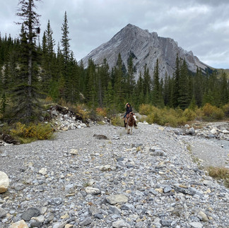
Eventually, the trail turned left, crossing the meadow on solid footing and we started the climb a series of steep switchbacks up, out of the meadow towards Dormer Pass. The view back down the valley was incredible. After the switchbacks, we continued climbing and crossed an exposed scree slope, eventually gaining the top of the pass. Just past the summit, as we started down the other side, we came across a small herd of mountain sheep, does and kids, on a high grassy meadow. Rodeo had lost a shoe on the pass, so we stopped to replace his shoe, have lunch and let the horses graze. While they were grazing another band of mountain sheep came down the side of a mountain and crossed the meadow. It was the most wildlife we’d seen in one place on our entire trip.
From there it was a long, steady descent off the pass into the Stoney Creek drainage. Once again, we were working our way down a stream bed, crisscrossing numerous times. There was less route finding required this time though as Banff trail crews had down a much better job of flagging the trail on the other side of the crossing. That said, we must’ve missed a flag towards the end of the day because we ended up in a spot where it was impossible to follow the creek through a narrow canyon and the only logical place for the trail to be was up on a ridge to the right. We either backtrack to find the turnoff, or we do a grueling climb to gain the ridge. It was late in the day; we were tired, the horses were tired, and we were on a nice grassy area beside the creek anyway, so we decided to camp for the night and figure it out in the morning when we were all fresh.
Nearly 10 hours on the trail today, covering 28km and climbing nearly 600m in the crossing of Dormer Pass. We’d walked a lot today, too, on most of the climb up Dormer and all of the descent to Stoney Creek. Very little of the day’s trail had been what you would call relaxing, or easy. We would all sleep very well tonight.


Best of Banff Tour: Day 8
What a difference a good night’s rest makes! We’d all slept great and finding the trail didn’t seem so daunting this morning. It was a beautiful morning, partly cloudy, no wind and a great forecast for the day. We were saddled and on the trail by 8AM.
After a fruitless, circuitous bushwhack searching for the trail, we concluded it had to be up on the ridge. Rather than go back to find where the trail cut off, we decided to climb. It wasn’t an overly long climb, but it WAS steep. We made our way up the steep, grassy slope, serpentining and slowly gaining ground in energetic climbing bursts interspersed with breaks to catch our breath. I was slow. My bum leg was really feeling it; it hadn’t endured a climb like this since Tornado Pass, more than two weeks ago.
We reached the top and sure enough, there was the trail. After a short jaunt on singletrack trail alongside a bison fence, we came to an intersection, the old Cascade Road. South would take us to Lake Minnewanka, the Bow Valley and Banff townsite; North would follow take us along the Cascade River to Flint’s Park turnoff and eventually back up to Windy cabin, if we didn’t take the turnoff. We turned north.
Talk about great trail. Wow! Wide, clear and no elevation gain. It was like a super-highway! Charlie was in the lead for much of the way, stepping out freely with the loose rein swinging to the rhythm of his trail devouring gait. We turned west at the Flint’s Park junction, following the Cascade River on another old service road to the Flint’s Park warden cabin. Here, we turned south, continuing along the Cascade towards Forty Mile Summit. Before reaching the summit, we turned off to our planned camp at Sawback Slide Path, a nice, flat willow meadow beside Sawback Creek, roughly a kilometer down from Sawback Lake.
We turned the horses loose to graze and set up camp. To give some perspective of how great the trail was today, we were roughly 6 hours, 15 minutes on the trail, covering 25km. The day before we covered 28km in 9 hours, 45 minutes. Today, we were in camp and set up by 2PM and even though we’d covered 25km, it felt like a rest day.
Later that afternoon, 4PM-ish, I was hanging with the horses, enjoying a friendly visit while they grazed, when suddenly their heads came up with full attention on the trail. Something was coming. Nothing at first, then a single fellow emerged from the trees. Seeing us, he stopped on the trail and shouted, “Thank goodness I’ve found you. I’ve been following your tracks for days. I’d like to talk to you about your vehicles extended warranty!”
I literally laughed out loud and invited him down to our camp. Well, talk about a small world. Turns out his name was Trevor and he was an electrician from Rossland, which is right next door to where I live, only 25km away. He was out for a 4-day, solo backpacking loop. He was travelling pretty simple and spartan in the food department, so we invited him to have dinner with us. We made tea and split his basic Mac & Cheese as an appetizer, then shared our Spanish Rice & Chicken for dinner. We had a great visit, then he left us to go set up his camp in the designated hiker camp area.
We decided to go check out Sawback Lake, so we left the horses in their electric fence enclosure and hiked up to Sawback. It was a pretty little lake at the base of a huge mountain wall. We didn’t stay long. We hiked back to camp and were crawling into our sleeping bags as the day’s light was fading, around 8PM. We needed a good night’s rest because with two passes to cross, tomorrow was gonna be a big day.


Best of Banff Tour: Day 11
Wow! What a storm?! It’s a good thing we changed our minds at the last minute, last night, and set up the tarp. Shortly after hitting the sack, the skies opened up and it POURED. I’m talking thunder, lightning and borderline torrential rain, the whole bit. Fortunately, we’d selected a good spot, on high ground, sheltered in a small cluster of pines. Peter and Chris were on the sides of our sardine-style sleeping arrangement and their bags were getting a big wet from encroaching rain, so we all scrunched into the middle to get away from the worst of it and stay as dry as possible.
The three of us just laid in our sleeping bags, under the tarp, listening to the ferocity of the storm. Then, when the worst of it subsided, we listened for horse bells. Ding ring-a-ding-ding ding, there they were, the sound of contented grazing. Great! The horses were still there and unfazed by the storm. This would be a lousy night to be chasing horses. We relaxed and went to sleep.
The storm continued through the night with intermittent squalls, but nothing like the intensity of the first blast. Well, at least that’s what Peter and Chris told me, because I slept like a baby. In hindsight, I think the dropping barometric pressure and change in the weather had added to the soreness in my legs, on top of the usual ache from the day’s use. The surgeon had warned me on one of my checkups that my new collection of plates, pins and screws might be an excellent, but unpleasant, weather forecaster, and also be a ton of fun going through airport security, but I haven’t tested that one out yet.
Anyway, I’d slept, in spite of the storm, and woken refreshed, rejuvenated, back to my usual self and ready to tackle the day. We broke camp, saddled the horses and were on the trail shortly after 8AM, under cool, partly cloudy skies. We enjoyed a good walk to start the day, get the blood flowing and stay warm.
With threatening clouds and squalls all around us, we crossed Cotton Grass Pass; that was the name of the sneaky, little pass that caught us by surprise yesterday. We were definitely getting into more heavily travelled area. We ran into a pair of lady backpackers as we crossed Cotton Grass Pass and two more couples at Red Deer Lakes backcountry camp. It sure was getting crowded around here; this was the most people we’d seen in one day, outside of Park Rangers, since leaving Lake Helen, on Day 1, ten days ago.
We stopped for a mid-morning grazing break at Red Deer Lakes camp. While the horses grazed, I made a proposal to Peter and Chris. My original route plan had this final stretch from Baker Creek camp to the Pipestone trailhead split into two 19.5km days. The weather had turned and tomorrow’s forecast was worse. We were back on trails that I’d ridden last year; the remainder of our route was generally decent trail-wise, all downhill, with no more mountain passes to cross, and we could possibly even shave a couple kilometers. It’d be a long day, but if we pushed hard, we could be out today.
There was no discussion; it was unanimous. Let’s do it!
With a renewed sense of purpose, we hit the trail, continuing north to Red Deer Lakes warden cabin, where we turned west. As we passed the largest of the Red Deer Lakes, the weather hit us with a cold, wind-blown mixture of rain and snow, adding to our commitment to make it out today.
As we approached the Pipestone valley, we were able to angle south, instead of going all the way to Little Pipestone patrol cabin and then straight south from there, saving us a couple kilometers of trail. The weather started to improve as we continued south, along the Pipestone River. The rain stopped, the wind let up, the clouds lessened and the sun poked through. We stopped for lunch and a grazing break in a grassy spot, in the sunshine, beside the river, resting and fueling up for the final, determined push to the trailhead.
As we continued along the Pipestone, across a large, willow-filled meadow, the usual southern view of the spectacular mountain peaks and glacier at Lake Louise was obscured in cloud. Instead, we were dazzled by the brilliant display of larches, in full, Fall splendor, on the mountains on both sides of the valley.
After crossing the big meadow, we entered the stretch that is the reason I don’t really care for the Pipestone valley. It tends to be a muddy, viewless, uninteresting grind through the trees at the best of times. After last night’s wind and rain, it was extra soupy with new deadfall to slowly work our way through and around. Eventually, we reached the Pipestone cross-country ski trails, taking familiar #20 all the way to the Pipestone trailhead and the waiting Adventure Rig.
We’d done it! We’d made it out in one day; a final push of 37km in 9.25 hours, including grazing and lunch breaks. All told, we’d completed our Best of Banff Tour in 11 days (2 less than planned), travelling 304km, crossing nine mountain passes, on all sorts of terrain and trail conditions, in all kinds of weather, with no injuries or other misadventures.
With huge grins and high fives all the way around, we unsaddled, packed our gear, loaded the horses and headed up to Lake Helen trailhead to pick up Peter’s rig. From there, we headed back to Banff where we put up the horses with a healthy supply of hay for the night. We unhitched the trailer and all piled into my truck for the trip back to Canmore and our hostel, where we showered, changed clothes and headed out for dinner and celebratory beverages.
Our destination was Das Schitzelhaus, a German restaurant that Peter, Tina and I had gone to on our GDT Adventure in 2022. They had been very impressed by the exceptional food, beer and authenticity; all very German, giving it an enthusiastic thumb’s up.
It was after 8PM and a beautiful evening, as we walked the 1.2km from the hostel to the downtown core, and Das Schitzelhaus. We’d already travelled 37km today, another couple kilometers this evening was a piece of cake. The dinner rush was just ending as we arrived. Yes, they had a table for us; yes, the beer was cold and yes, the kitchen was still open. A cold beer and freshly-made soft pretzel to start. By now, the place was empty, except for us. Our appetizer was followed by another beer and fantastic dinner. I can’t remember what we all had, but it was fantastic. Our waitress was amazing; just the right mix of attentive, knowledgeable, fun and sass. We asked to meet the chef so we could thank her for the amazing meal. When all was said and done, all three staff came out and said how much they enjoyed us and they couldn’t think of a better group of guys to close out the evening with. Then, they brought us a round of liqueurs, on the house, as a thank you. Wow!
We walked back to the hostel and turned in for the night.


Comments